Alpine Lakes Grand Tour

All the beauty sandwiched between Snoqualmie and Leavenworth is well worth the trip. The Grand Tour is a tough 90 miles and 23k feet of vert and spans from lush verdant cedar and fir groves to harsh granite and snow passes, around pristine blue lakes and through high and dry ponderosa and madrone areas prone to burn.

Dudley Spire/Axis Peak Ridge seen from EightMile trail descent.

The route is described by UltraPedestrian Ras Vaughn as part of his UPWC series. There is also a description of the FKT completed by Christof Teuscher and Megan Lacey. I completed the challenge in an unsupported manner but with the company of a couple of my friends with whom I shared food, a stove, and a tent. For those who want support there are a couple opportunities along the way since the wilderness route is perforated at a couple points by forest road access. I used a Garmin Forerunner 935 to create record of our route which can be found on Strava and Garmin Connect.

From Snoqualmie to Leavenworth, there’s a couple dirt roads that you cross, but otherwise lots of wilderness!

We completed the route in 75 total hours with 40 hours of hiking time and three nights camping. We travelled pretty light- fastpack style, but aside from me jogging a few downhill sections, we hiked everything. I think this was probably for the best since my feet are having some persistent blister issues and it is also a shame to ruin such a beautiful route by rushing through it.

Sharing gear on this trip made our life easier. My friend Pat brought an ultralight tent, the MSR Carbon Reflex that is advertised to fit three, but practically fits two big guys and their gear comfortably. It weighs 2.3 pounds, and between splitting the weight between us, it is like carrying nothing at all. My other hiking pal Duy brought a stove that we all shared. Many hands make light work, provided you all stay together as a group.

Another observation of the trip is the vast difference in human volume between popular trails and lesser known trails, even though both might be similarly beautiful. For example, we saw many hikers on the PCT stretch, even though the previous stretch through Dutch Miller Gap and along Lake Ivanhoe was a much more scenic route and yet we saw only one group of hikers there. There’s something to be said about the path less traveled but I won’t go deep into it here.

Lake Ivanhoe: beautiful place with nobody to be seen!

I should mention the berries as well. We hiked during August 19-22 and there were berries all over. Mostly we ate huckleberries and blueberries but also thimbleberries and a few salmonberries. There is a stretch of trail on the descent from Paddy-Go-Easy Pass including Meadow Creek Trail and Jack Creek Trail that was literally dripping with huckleberries during our traverse. There are ample opportunities to turn your hands, mouth and poo into a hot purple mess if you time your trip right.

Some of the many thimbleberries I stopped to pick

Overall the route and trails were fairly easy to follow. I goofed up one section by hiking on the 1030 road instead of Middle Fork Trail for a couple miles. They are about the same distance but I’m sure the Middle Fork Trail would have been the more scenic route. A couple of the trails were a little overgrown such as the Rock Creek Trail and some of the Middle Fork, and the Jack Ridge Trail was difficult to see through the meadows since it has been consumed by grass and flowers, but trivial to pick up with a GPS track at the meadow edge. I don’t think trail conditions slowed us down appreciably at any point, in fact we were far more slowed down by berries as well as the jaw-dropping beauty of some of the vistas.

The Jaw-dropping Dragontail Peak, Aasgard Pass et.Al. seen from the EightMile/Jack’s Ridge Pass.

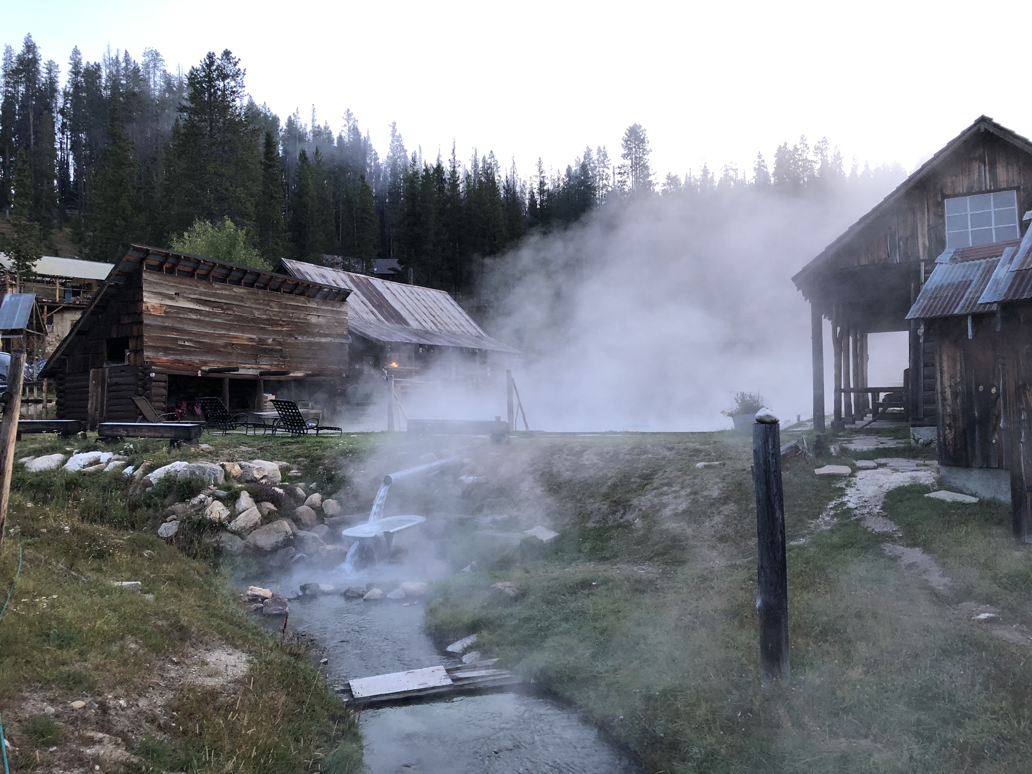
Regarding permits and trip planning, it would be grand to camp at Colchuck lake. We did not have permits, so we camped the final night outside the Enchantments permit area in a little spot along NF7601 near the 8-Mile trailhead. If you attempt the route, keep in mind the constraint that you need to hike through the Enchantments in a single shot if you don’t have permits. I think if we had gotten permits to Colchuck lake, and also made reservations to Goldmyer Hot Springs a couple nights before, it would make the Tour even more epic. We did the trip in late August, and the weather was perfect for us. Cool nights and even a little rain during one night. The days were pleasant and mostly bug and sweat free.

Last day. Colchuck Lake, Dragontail Peak and Aasgard pass in background.
Meadow traverse near EightMile Peak
A friend dropped by camp. Meta-picture.
Same friend. Different angle.
Clouds. Peaks. Trees. Repeat.
Trout Lake. A very beautiful place and no hikers to be seen anywhere nearby.
Pat, Duy and I on our final day, hours from the car… one of the lakes in the Enchantments.
Hiking the Enchantments. Thanks @Duy for the great photo!
More of that magic Enchantments trail. Thanks @Duy again for the photo.

2021 Desolate Peaks

A couple months prior to the event, I received an invitation to the Facebook group Desolate Peaks. I think Scott Martin probably invited me, and the group description had me hooked instantly:

The 17-step program eluded to is this amazing peak-bagging challenge laid out in the Desolation Wilderness Southwest of Lake Tahoe. The standard challenge is 17 peaks with a time limit of 30 hours (with an option of 4 more called Lucifer’s Challenge that nobody has yet completed). There are two checkpoints where you can access a drop-bag or drop out. The coolest part to me is that there are lots of options on how to get between the peaks and you don’t have to take a specific route. For example you can take an established trail which is a longer distance or you can choose to bushwack and route-find that yields shorter distance but more difficult terrain. It’s almost always a trade-off between technical difficulty and distance. All that really matters is that you get the peaks as fast as possible, which is verified by GPS or geolocated images. I created a map of the peaks and my route here: https://caltopo.com/m/4JTL

The peaks and my route. This is located just SW of Lake Tahoe, most of it between 7000′-10000′ elevation.

Around 60% of the route I took was off-trail, so navigation and familiarity with the terrain is essential to completing the challenge. I spent over a week fast-packing the course and route-finding prior to the event. I don’t think it’s likely that many people can just show up to this without course knowledge and complete it without assistance from others. There’s simply too many wrong turns to take and mistakes to be made, at least at my skill level.

A beautiful place. And all that granite without any trails will tear up your feet!

Compared to any other race beside maybe my first ultra, Desolate Peaks may have caused me the most pre-event anxiety. Just hiking a portion of the course is hard for many reasons including the elevation, exposed scrambles, technical ridges, heat, smoke, hard granite, endless talus, bushwacking and the general brutal nature of off-trail adventuring. Out of this anxiety I spent a lot of time scouting the route ahead of time and buying stuff like an extra headlamp, a Garmin InReach Mini, and even some calf compression sleeves to afford some shin protection during the bushwacking sections (I never actually wore them, I just bled like everyone else).

There were 27 entrants, and 20 starters lined up at the gate at 6 AM on Saturday. (Spoiler alert: 2 finished 17 peaks, 8 finished the 11-peak “fun run,” and the rest bailed, mostly due to smoke)
Mt. Price (on the left) is the first summit. This photo taken from the North. You can climb up the bowl to the saddle or go around the back of the ridge via Smith Lake.
Most of the lead pack at Mt. Price summit. So. Much. Talus.
En Route to smoky Agassiz from Price. Pyramid Peak just poking out over Agassiz’s left side.
Earlier, I met this fellow climber on the third summit, Pyramid Peak.
After Pyramid Peak, it is a long steep talus descent to Lake Aloha. Granite for days!
After a bunch more peaks and a really difficult traverse, I was more than happy to arrive at the first checkpoint!
Some really beautiful country between the two checkpoints. And another gnarly traverse.
After the final checkpoint, I teamed up with Joel T. who showed me the scramble route up the gully to Catheral Peak. We gained 1800 feet in about a half mile of distance… way better than going around the long way.
Joel T. and a full moon at the top of Jack’s Peak, around 2 AM. We took a brief dirtnap here before the final section. The final section was tough, no trail for quite a while and super steep sections!
Joel and I with the second fastest ever finish time with 25:26.
Picked up a nice dirt tan along the way. Until next time, Desolate Peaks.

The 43 mile Desolation Peaks took longer than most 100 mile mountain races that I’ve run. For contrast, I completed the Cascade Crest 100 with ~23,000 ft of elevation gain in 23 hours, but this 43 mile route with 16,900 ft of gain took me more than 2 hours longer. I don’t think they’re comparable sports- there were only a couple miles that I could actually run of Desolation Peaks. Most of the time it’s hiking and climbing and scrambling and hopping boulders. The course was way more fun than a standard ultra race to navigate and generally experience, and I’m looking forward to finding more challenges like this. I highly recommend the challenge, and if you can spend some time scouting out and running the challenge you’ll probably enjoy it too. Look up Desolate Peaks group on Facebook for more information.

Feel free to use my map/activity data at these locations:

https://connect.garmin.com/modern/activity/7189429461

https://strava.app.link/frN7L8qEiib

https://caltopo.com/m/4JTL

2020 IMTUF 100

The 2020 IMTUF race had substantial differences from previous years. Race directors Jeremy and Brandi Humphrey changed the course to a new start/finish due to closure of the Burgdorf Hot Springs. A new start/finish and camping area was established at Jug Mountain Ranch for the 2020 race. This resulted in course changes; Jer and Brandi had a contingency plan course already established before COVID-19 due to fires that had threatened the course in previous years. This contingency course is known as the “Supercourse,” and in my opinion it had no problem living up to its name.

Check out the teeth on this monster! Nothing like eating a 3500′ climb for breakfast.

The Supercourse had an additional 2000′ of gain and also added miles of cross-country travel without trail. Around 40 miles of the 2020 race were on trails that are not part of the normal course. A notable section is a quarter-mile scramble down a massive talus field after the Jug Mountain summit. It brought a tear to my eye, it was a beautiful thing to see in a 100-mile race. Speaking of 100 miles… its more like 105-108 miles. My neighbor Nate and I both wore Garmin 935’s and both were around 108. I got around 108 in 2019 as well using the same watch. So this is a typical result for distance in an IMTUF race; they don’t skimp on mileage and you can plan on getting your money’s worth with this race.

Another notable difference for 2020 was the feel of the race. COVID-19 posed some serious risks, and in my opinion Jer and Brandi rose to the occasion to provide a safe environment for the runners and volunteers. The start/finish had plenty of room to maintain distancing, and there was high compliance for distancing and mask use by the runners and spectators. A wave start was implemented to spread the runners out (~190 toed the line, the most ever for IMTUF). Aid stations had a protocol for hand sanitizer and mask use, and almost all runners I saw had no problem with following the rules. I was able to stay out of any dense congo-line situations in the race, and I felt comfortable with the risk of transmission during the race.

The safety protocols affected the feel of the race for me. I didn’t give hugs and high-fives to the other runners I knew. I didn’t meet as many people as normal, or hang out nearly as much. There wasn’t the same collegiality formed by drinking and eating with others. The finish line felt a bit sterile as normally there are lots of people hanging around exchanging stories and such. But this is all to be expected, and I’m grateful to have had the opportunity to run the race at all, with so many races being cancelled and my last-minute sign-up. Most of a 100 mile race is spent alone (for me anyways), so it’s not a big deal overall.

Nate Sustersic’s socially distanced finish

My neighbor Nate talked me into signing up for this at the last possible minute. I was the last person admitted onto the waitlist at #57 with less than three weeks before the race. I think I spent more time watching Ultrasignup than I did actually running the race. I even made some desperate plea bargaining on the IMTUF Facebook page to ask any entrants not planning to attend to withdraw from the race. Two days before the race, I got in! Wow… from DFL on the waitlist to a toe on the line! Thanks Jer and Brandi!

The field was pretty stacked. Typically I’ll be in the top 20% of the entrants or so. Not this year- I was back around 50%! There were a lot of seriously fast runners out there. I think this race funneled in a lot of talent due to most of the hundo’s being cancelled this year- people were itching for a chance to get their legs sore this year! For such a stacked field though there were a lot of DNF’s. More than half the field DNF’ed. It was a hard course and a hot day but this was more DNF action than I would have predicted. I would have liked to see an exit survey to have some idea what is going on there.

I won’t say too much more here about my personal race. I enjoyed much of it and only had one rough patch on the Crestline traverse due to heat, dryness, and a poorly-timed faceplant. I took a nap just below the Snowslide summit at 3 AM- napping during a race is a first for me. I got to run with my neighbor Nate during the afternoon which was a real highlight. We got selfies with the goats. I ate lots of food, and the watermellon, pizza, and ramen noodles were delicious. It also got pretty smokey the second morning thanks to the Oregon wildfires. I beat someone at the finish by the magic of chip-timing. He was in the first wave, I was in the second wave, and he never saw me coming at the finish. I never saw him either until after I finished! It was a great race and I recovered quickly. Bree as always was a huge help, she assisted with planning, and throughout the race, and after the finish.

Without further ado, I’ll switch to a picture narrative now. Thanks for reading!

Climb to Ladybug Mountain, before Jug mountain.
The trail-less cross country traverse from Ladybug to Jug Mountain
Scramble for breakfast: Jug Mountain Summit
I laughed out loud, the talus scramble coming off Jug Mt. was awesome!
View from the first aid station at Louie Lake. Great spot!
The descent off Jug to Lake Fork was very runnable provided you could keep your eyes on the trail…
The Slickrock climbing monolith, just after Lake Fork Aid
Typical socially-distanced aid station. I catch up with Nate for a while here at S. Crestline Aid.
Nate and I hiking up the first Crestline climb toward the goats.
Hey goat, don’t drink all my water!
Nate and goats. Seriously, how cool is that?
The Crestline is an amazing stretch of trail. One of my favorites.
More Crestline
Smokey sunset after North Crestline Aid
The next morning, with more off-trail climbing to the summit of Boulder mountain.
View from Boulder summit. Smoked in pretty good.
Trail-less traverse from Boulder Mtn to the final aid. Just follow the pink ribbons, they said… It’ll be easy, they said…
The final few miles had some really nice trails like this to the finish.
The finish area, plus smoke.
Finito!
The ol’ almost fist-bump with Jer.
New buckle for second-time finish.
I like them both. I think I like the detail of the first year buckle more, but the black looks really cool too.

Forest Park All Trails Challenge, and my 2020 Birthday Run

It started innocently enough with a geometry problem. A real head-scratcher: what is the best possible route that will travel the entirety of every trail of Forest Park in one push? Wouldn’t it be fun to run every trail in Forest Park this way? After all, the Forest Park Conservancy sponsors the All Trails Challenge- a yearly event where hikers can track their progress in completing all 83 miles of trail inside the park, so there’s precedent for hiking it… so why not run it all in one push? And what route would be the best to take?

There is a lot of literature on route optimization. It’s economically important and there is a branch of mathematics called graph theory that includes this subject. Similar problems are solved routinely for delivery services and logistics operations to minimize costs. Euler is credited as laying the groundwork for graph theory with his proof that no solution to the Seven Bridges of Königsberg problem existed (he solved it in 1736 at the age of 29).

The Seven Bridges of Königsberg problem is as follows: Is it  possible to take a walking journey across all seven bridges without having to cross any bridge more than once?

Euler defined the land masses (the nodes) as A, B, C, and D and the bridges (the edges or links) as a-g. It’s a little easier to see what’s going on with the interconnections once it’s defined this way, and I’ve drawn a graph below to help show the interconnection between the land masses and the bridges.

Seven Bridges Graph

What Euler argued is that in order to travel each bridge (the edges or lines in the graph) once from one of the land masses (the nodes), then you must be able to enter and exit a given node an even number of times. You can only enter and exit a node an even number of times without repeating an edge (the interconnecting lines) if there are an even number of edges connected to the node. Since in the example above the nodes have an odd number of edges, there is no way to solve the Seven Bridges problem without repeating a bridge.

If a graph has nodes that are all even, then it is considered Eulerian, and a solution exists where each edge can be traveled exactly once in such a way that all edges of the graph are traveled. For our purposes this is an optimal solution to our problem of how to run every trail in Forest Park in a single push.

Unfortunately, Forest Park has lots of odd nodes, so at first, this seems impossible. In the map below, we can see some of Forest Park. I have only shown a small part of the park here to keep it simple for now.

The Forest Park Conservancy has a list of all the named trails that are part of the All Trails Challenge. From this list we find that in this part of the map, we must cover the Wildwood, Upper McLeay, Lower McLeay, Cumberland, and Tunnel trails. I have added nodes to the map at their intersections and endpoints below.

Then I connect the nodes with the appropriate edges to reconstruct the trail network as a graph. I’ve also added the length of the edges to the graph as well.

The next step is to identify all the nodes that are even (green) and all the nodes that are odd (red). Entry and exit nodes get +1 edge added to them (you can think of them being connected together through an edge). So node A is actually degree 2 (even) and node F is degree 3 (odd) since we have chosen to enter and exit the graph by these nodes. More on entrance/exit strategies later.

Since there are six odd nodes the graph is not Eulerian, so there is currently no way to create a route that traverses each edge once. If we pair the odd nodes by adding edges between them, then we can create a graph that has all even nodes. The trick to adding edges between the odd nodes is to do so in such a way that it minimizes the sum total distance of the added edges.

For example, I need to pair node F with another node. I can choose to pair with node E, since it’s close. Then I need to pair node D with another node, but I can’t use node E since it is now paired to node F. So I pair D with H. This leaves I to be paired with G. The sum of the added edges is 1.46 miles.

Alternatively, I could pair node F with node D through node B. Then pair E with H and G with I. The sum of these added edges is 1.52 miles. Since this is more added edge distance than the previous route, it is less optimal from a minimum distance perspective.

With the minimal length addition of edges between paired odd nodes, an optimal route can be found. This pairing adds 1.46 miles to the total miles of the route. A and F are enter/exit nodes so they have +1 edge added to them to make them even.

Look outside the box.

This is where I made my first mistake by failing to look outside the box. I did not consider running up Cornell Rd from the tunnel node G to the finish node F. I realized my shortsightedness while on the tunnel trail, but by that point it was too late since I still needed to backtrack in order to pick up the double edge between E and D. If we consider running up the road (it could be a little risky with traffic) then we have this graph:

The addition of Cornell Road shortens the added pairwise edges to 0.93 miles. Oops!

Many routes are optimal

Now that the odd nodes are all paired, we can make a route that uses each edge in the graph.

At this stage it’s not too important the order in which the edges are completed since we’re only optimizing the total distance. Here’s another route with the same outcome- same paths covered, same distance, just a different order.

In fact, there may be many optimal solutions to an Eulerian graph, depending on the number of nodes and edges. More optimizations than distance are possible as well. For example some trails may be more optimal to travel twice instead of another due to hills, technical footing, or some other preference. These preferences can be weighted by adding or subtracting into the “distance cost” of the edge.

The Run

The map distance was about 108 miles, and the GPS result was 102.4 miles (with some poor GPS around FL #1). The altimeter-based vert was measured as 17,543 feet.

You get the idea with the route planning. I probably spent more time planning than I did running. So at 6 AM on my birthday Bree dropped me off at the zoo and I ran. And ran and ran and ran. Bree set up aid stations along the way at some prominent points (Thurman gate, bottom of FL #1, Newberry Rd, etc…). I had some great company along the way as well: my buddy Rick brought me popsicles and grilled cheese which was amazing. My buddy Scott ran with me a couple hours into the night which was cool. And Tom came out to cheer me on!

I got tired around 3 AM and took a dirtnap for an hour at the intersection of Leif and Tolinda for about an hour. This was the first time I have slept in a city park when I wasn’t drunk, so that’s exciting. The next morning Rick found me in my zombie-stupor-shuffle wandering around the North park and we did some more miles together. Bree picked me up and took me home when I was done. Thanks everyone for supporting me! It took me just under 29 hours to complete the route. I think I can spot the transition from Type I to Type II fun in the pictures below…

The Beaver Slam of UltraRunning

Oregon has lots of great things, like the Seven Wonders of Oregon, dynamic ecosystems, vast forests, and great small towns with fun names like Boring, Dufur, Powder, and Zigzag. We have the largest cheese factory in the world. Let us not forget the cultural weirdness of Portland, or that we sport the highest state tax rate in the nation for the working middle class.

North and Middle Sisters seen from the Cascades 100 course above Peterson Ridge. (Taken by me during my Oregon Timber Trail bike trip)

But alas, let us shift our thoughts towards the things that Oregon does not have. We do not have a state sales tax or a Real-ID compliant drivers licenses. We do not have freedom to pump petroleum into our vehicles unassisted. And the real kicker here is that we do not have our own locally sourced, shade grown, non GMO, conflict-free, Oregon-based “Grand Slam of UltraRunning.”

I plan to put an end to this travesty. This year I made it my goal to do my own Oregon Grand Slam. I’ve been playing around with the name a bit, one of my favorites so far is calling it the “Hindsight 2020 Slam” because it is a terrible idea and it’s the year 2020. But it won’t stand up well to time. So I think it should be called the Beaver Slam because it’s our state animal, and they slam the water with their tails and are generally awesome little critters. Maybe they don’t slam the water but more of a slap. So the Beaver Slap?

The plan is as follows:

RaceDate
Slug.Run (> 100 miles)April 18
Old Cascadia 100June 20
Cascades 100 August 29
Mountain Lakes 100September 19
The Beaver Slam

It was a toss-up between Pine to Palm and Cascades 100. I ultimately decided on Cascades 100 because P2P is the weekend before ML 100, and it seemed like too much to pack in all at once. My main goal is to finish these races without any significant injuries and it seemed like putting 100’s back-to-back would really be poking that bear with a stick. Also, there is a personal thread that joins Old Cascadia, Cascades, and ML 100- I biked on some of each of these courses during a 9-day bike packing trip of the Oregon Timber Trail that I did last year.

The trail down Crescent Mountain, part of the Old Cascadia 100 course. (Taken by me during my Oregon Timber Trail bike trip). There were miles of old growth, blooming rhododendrons, beargrass, and lupine.

Slug.run should be interesting as well. It’s a backyard-style ultra (4.17 miles per hour until you drop), and it looks like plenty of good competition there to get me well over 100 miles. I’ve never run a loop for 24 hours before, so it will be interesting. And at $75 for an all-you-can-eat buffet of running, it’s a heckuva deal! I’ve already started training for Slug.run by practicing my race walking. In the evenings I have been walking a 4.17 mile course I have set up in my neighborhood. While listening to podcasts and music I can easily walk the course in 58 minutes, which gives me a comfortable 2 minutes to grab something from a cooler if I want it. So maybe more of a Slug.walk for me.

Slug.run… but maybe Slug.walk. How about Slug.slog?

It should be noted that Oregon now has four “true” 100 mile races including Pine to Palm. Unfortunately three of them are all clustered within a 22 day-ish window around Late August and September. I’m not to that level yet, so there’s an opportunity for someone else to take it there in the future. So I opted for a last-person-standing run to give some recovery instead of a September cluster.

There’s also quite a few timed runs and last-person-standing type runs in Oregon that can easily be taken to 100+ miles. My decision to do Slug.run had more to do with it being a new race and opportunistic timing. Like my decision to not run P2P, it has nothing against these awesome races, they simply didn’t fit into my personal schedule opportunities for one reason or another.

So between these four ultras: Slug.Run, Old Cascadia 100, Cascades 100, and Mountain Lakes 100- I am embarking on a journey predicated upon some of the most questionable decisions/choices I’ve ever made. In hindsight, I’m sure 2020 will be hard to forget for one reason or another. I’m truly excited to embark on this fool’s errand, and I’ll keep the blog and the NW DirtChurners newsletter updated as I complete each leg of the Beaver Slam.

2019 IMTUF 100

2019 is a “counterclockwise” year at IMTUF; the race alternates directions every year. The climbs tend to be more gradual in this direction and the descents are tougher since they are steeper and very rocky and technical. For this reason, some racers consider the odd years to be the TUF’fer direction, but it’s not totally clear to me that this is actually the case. The distance of the race isn’t totally clear to me either, but typical GPS watch distances I saw on Strava are in the 105-107 mile range and in the neighborhood of 20,000′ of climbing.

2019 Counterclockwise loop

Aside from the difficulty of the route, it is a well-organized affair with a community feel that is located in one of the most beautiful settings I’ve ever visited. The start/finish of the race at Burgdorf Hot Springs, which is is as rustic as it is iconic; it oozes history and ruggedness as well as offering hospitality and camping. Thinking about soaking in the hot springs at Burgdorf helped keep me moving forward at 4AM during the race!

Burgdorf Hot Spring in the cold morning. PC: Bree Mclean

Arriving a couple days before was a good idea. I traveled with my friend Rick, Bree, and Kathy (Bree’s mom), and arriving early gave us time to explore the area and the course a little bit before the race. As it turns out, Brundage mountain is just outside of McCall, and I was pleased to see my surname emblazoned on everything from ski resorts to shot glasses.

Bree and I, at Brundage mountain before the race
I ended up buying a “Brundage” shirt, and there was no shortage of things with my last name on it in McCall.

Brundage Mountain has some fun things to do during the day- you can ride/rent mountain bikes, or hike the hills, or play disc golf. They also had a childcare facility that was open as well and the pro shop was open when we visited. There is also a fire lookout on the top of the mountain with nice views.

We did a demo ride on this electric beast at Brundage Mountain. That thing flies up the hill! You can make it to the top on that ride faster than the chairlift.

The camping situation at Burgdorf Hot Springs is nice. There are maybe a dozen designated sites in the trees, and after they fill up there is an open field area where the rest of the people fill in. We ended up getting one of the last designated sites on Friday afternoon around 3 PM; the designated sites have more space and trees between them so it makes for a quieter camping situation (not that I can sleep that much before a race anyways). The Friday night pre-race briefing was pretty chill, you sit next to the hot spring and get the low-down on the course and aid stations and everything for an hour. We took care of our drop bags and check-in at this time so we didn’t need to think about it on the race AM.

And before you know it, these things get under way. I hung out at the start line next to a blazing burn barrel to keep warm in my shorts, it was somewhere in the low 40’s/high 30’s at 6 AM when the race started. An elk horn blow later and we’re off!

The start of 2019 IMTUF 100!

As the dawn breaks, the course heads up towards Bear Pete Mountain and Cloochman Saddle. My heartrate was about 10 beats per minute too fast, but the effort seems about right for 100 mile pace. I suppose increased elevation will raise heartrate a bit for a given pace, but in hindsight I probably should have gone even slower. A few miles in and I already got my feet soaking wet in a muddy stream crossing.

Jereme Monteau, crushing it as always.
Up on the ridge and headed to the saddle, the trail is runnable and in great shape.
Cloochman aid: why yes, I’ll eat a bunch of bacon!

From Cloochman to UPay it is mostly fast with a little connector trail that’s technical. After UPay, it’s fast until the stream crossing at the start of Terrible Terrence Trail and the climb to North Crestline.

Lots of places to cruise between the first climb and the Crestline climb.
Me crossing the stream just before the Terrible Terrance Trail starts.
Jereme Monteau, crushing the Crestline climb.

The North Crestline Aid station had lots of good food options. This is the last real aid for a dozen of miles or so, so load up! They also had a great band playing for us there. The Crestline is rugged and super beautiful and one of the great features of this race.

This band rocks!
Cruisin’ on the Crestline
Tough trail, but who cares- it’s beautiful!
I swear there’s a trail through there… it’s just kind of hard to see at points!
God’s country

Coming out of the Crestline I took a detour but there was a nice view so it was great. The descent after Fall Creek Summit is fairly treacherous, but not too bad if you take it slow. It’s not runnable in sections since it’s steep and the trail is not well maintained. Once you get down to the road, it’s a forest service road cruise into Lake Fork aid. I was feeling kind of hot, and I remember the fruit tasting great at the aid station- cantaloupe and pineapple and watermellon! After Lake Fork is a long section through the Snowslide pass/lake area. I started feeling good through here so I decided to move faster. I caught up to my friend Rick on the Snowslide climb which was a mistake; I should have focused on maintaining my pace. Oh well, live and learn.

Rick, en route to Snowslide Summit.
Rick nearing the top of Snowslide Summit
Snowslide Lake. Wow, this course is special!

As I eluded to, I took that section too fast. Strava leaderboard fast. Oops! By the time I made it to the Snowslide Trailhead aid station my gut started doing funny things. I spent five minutes sitting in the bathroom, and I was having some trouble eating at this point. I didn’t quite get the memo still, so I took off out of the aid station going too fast, headed to Duck Lake in the failing light. At Duck Lake I spent another few minutes sitting in the bathroom, and no food was going in.

The 40 or so miles after this I managed to eat a few gels and two cups of soup. Maybe 500 calories in 40 miles- so Duck Lake was pretty much the end of the race for me. I ended up walking a lot to the finish but never really was able to solve the stomach issue after it started. I think I pushed too hard and my stomach shut down prematurely.

After Upper Payette Aid #2 was a nice climb to the Diamond Ridge Goat station. I got my selfie with the goats and tried to get a kiss but goatie wasn’t having no shenanigans.

Just one kiss… please?!?

The last 30 miles after you get off Diamond Ridge are somewhat runnable; if you can still run. The Willow Basket is a rats-nest of trails, so make sure you get help from the folks at the aid station. After the 10-mile loop at Willow Basket, it’s another 10 mile grind to the finish line. Ruby meadows is scenic, but I was pretty much done at this point and just jog-walked it in.

Finally done! I need a bath!
Pretty much perfect right here.

Recovery was pretty quick from this race for me- the stomach issues kept the devastation level down on my legs. We had beers Sunday night and celebrated by opening a “Tough Love” by Crux using our new IMTUF 100 buckle!

Jereme Monteau and race winner Ryan Kaiser, celebrating with Tough Love beer, chicken wings, and pizza!

Lawetlat’la Endurance Run- 2019

One of the first things that white man did in the PNW was to give the mountains white man names. But the mountains already had names, and for what is commonly referred to as Mount St. Helens, it was previously dubbed Lawetlat’la by the Cowlitz people who knew it long before. The Klickitat people already called it Loowit or Louwala-Clough. All of which are fine names.

In any event, another odd habit of people is to very respectfully (since this is ancient spiritual ground) run around and summit the breached stratovolcano. This is both great fun and not so great fun at the same time; it is amazing out there, but also some of the most challenging rocky trails and canyon crossings in the area.

Try running fast on this “trail!”

The format of the Lawetlat’la Endurance Run is a summit, followed by a circumnavigation, followed by another summit. It is an invitational event boasting 44 miles and 16,000 feet of ascent that are to be completed in 18 hours with no aid or dropped bags. One of the main challenges is just getting a climbing permit for the event, which are in short supply during the summer.

The course profile. Note the two devil’s horns- this thing is evil.

The 2019 run was my third attempt at this course. I made failed attempts in 2016 and 2018, due to the ruggedness, heat, exposure, lack of water, unpreparedness, etc. At the end of the circumnavigation most people drop before the final climb; at this point the campground with your chair and food and beer is only 20 minutes away and its so much easier to call it a day than to climb another 4000′ up an unforgiving rockpile. Psychologically, it’s a very tough crossroads.

My 2019 attempt almost failed as soon as it started. I made a last minute decision to save weight by ditching my warm clothes after I felt how heavy my pack was. I knew the forecast was 30 mph winds and 40 degree temps at the summit with rain. It seemed nice enough in camp, so I left the jacket and hat in my car- why drag extra weight along for 44 tough miles? Oops. I also had counted about 2500 calories and that worked out to about 150 an hour. I remember thinking it would all be fine and work out in the end- yeah I’d be cold and hungry but you just kind of push through those things and conditions will improve eventually. So, really bad decisions were made from the start when I was feeling pretty optimistic about things.

2019 starters. At 4 AM the camera was just waking up.

One of the fun things we do at camp the night before is to draw a picture that predicts how you will DNF. This year I predicted that too much Gu would send me into a diabetic coma, which was pretty far from the truth. I would have been happy to have extra gu.

Freezing to death would have been a more accurate prediction.

The first climb turned sour about halfway up. It clouded in thick and I became soaked to the bone. Soon afterwards the 30-50 mph side-winds numbed my hands and arms such that my biceps hurt to contract them and my fingers would not move at all. The whole thing was quickly at risk, so I pushed hard to stay warm and my heartrate was inching up towards 85-90% max. Great effort for a workout, but not where you want your intensity to be at the beginning of a 16 hour run. At the edge of the crater, I met the three front runners that had already summited and were beginning their descent. There were grim looks exchanged and we all were moving quickly to get the hell off the mountain ASAP. It was nasty. Four of the starters did not complete the first summit which I believe set a new record for fastest DNF.

Scott Martin was at the bottom taking pictures and checking in with the runners. I was getting some food since the feeling started returning to my fingers and I could actually use them again. The low clouds persisted and I stayed wet until about 3/4 around the mountain in the afternoon. Rick and I would yo-yo back and forth all the way around the mountain. He was moving a little faster, but I wasn’t taking any breaks, so our relative pace averaged out and we saw each other several times around the mountain.

Wet low clouds all day. Spirit Lake from the Loowit trail. PC: Scott Kruis
Flowers in the pumice and low clouds. PC: Nils Wagman
Bushwacker descending by rope into one of many canyons. PC: Scott Kruis

At the completion of the circumnavigation, I didn’t even look toward the camp. I put the horse blinders on and accelerated up the mountain. Rick caught me and we did the final climb together. I thought it made it go faster to suffer with a friend. We chatted and complained about our legs and before I knew it I was out of food and water. I started eyeing the melting snowfields and even attempted to collect some water from a trickle, which resulted in a few gulps of dirty-brown but ice-cold melt water and a mouth full of gravel. Rick told me to not even look at the snow melt since we already knew it would not go well, and plus who knows how many people pooped on it. The whole thing reminded me of the sirens in the Odyssey, so I tried to ignore it the best I could.

Final summit!
What a view! The clouds finally burned off.
Rick and I are really glad to be done!

We made it back to camp just past 8 PM. Rick improved on his previous finish time by almost an hour and a half; he is also the first person to finish the Lawetlat’la Endurance Run twice within the cutoff time. I got a PR for a Loowit circumnavigation (just over 8 hours), and I’m super stoked to have simply finished the Lawetlat’la.

2019 results. FKT by Eric with a blazing time of 11:23. I am very happy with my finish.

Changes are in store for next year, Scott has already hinted at that. I wonder if he will add another summit- it would bring the total climbing over 20,000′ and bring the distance up to 50 miles and further entrench it as the toughest run in the area. I suppose he could play with the cutoffs too, or add additional trail to the circumnav. Time will tell. For now, I’ll focus on reducing the swelling in my feet.

The signs of NF 2233

Late in the fifth day while biking the Oregon Timber Trail, I had a several thousand feet climb up to McCoy shelter from Idhana on the lovely NF 2233. It was paved for about half the way, and there was a national treasure of road signs that have been shot up by the locals.

It starts innocently enough. A smattering of bullet holes. Notice the artful grazing angle holes just off center.
Someone tried to stanch the bleeding by using a stick to plug the bullet hole. What does that little sticker say?
I think they need to make the sticker lager. There is no way the gunmen could read this while hanging out of a moving truck and aiming a gun.
This sign was patched. But then the patches failed (except for the one at the top).
This sign got a nice patch job. Then it got shot again, twice, sometime after the patch job.
This sign had it coming to it- it got shot from the front AND from the back.
If you aren’t a great aim you can always trust birdshot to get the job done right!
However, the back of the birdshot sign is still fairly structurally sound. Mostly cosmetic damage.
A unique expression of the artist channeled through two types of shotgun shells. Like a painter trying to mix water colors and oil paints, this sign is truly a work of art.
This sign has a single bullet hole on the left. I believe the US flag in the corner juxtaposed patriotism against the gunmens’ desire to shoot at the sign. The flag printed on the sign appears to be an effective countermeasure for gun violence against signs.
Like all good things, even the vement ends someplace. And that sign gets shot too.

BPA 24

If one is fun, imagine how much fun 24 is!

During my Cascade Crest 100 training in 2018, it became obvious to me that this would be the perfect birthday run for 2019. The challenge is to run up and down BPA road: from the gate to the picnic table and back to the gate. It’s about a mile and 850′ of gain from the bottom to the top. You get 24 hours to complete 24 laps. Easy pace, easy vert.

I created a facebook page and recruited as many runners and hikers as I thought would give it a shot. Sean Harraser helped me create a logo for the buckles, as I was thinking I would have custom buckles made for the finishers (until I got the $$$ quotes for them). Instead, I ended up printing out laminated “buckles” that went with the finisher beer awards in the end.

Sean Harraser’s buckle logo

Since it was supposed to be a birthday run (the 25th is my birthday), BPA 24 started on June 24 at 6:24 PM, just after work (on a school night!). Many of my best friends came out after work and promptly at 6:24 on 6-24, BPA 24 was underway.

The starting field. Several others (Rick, Pete, Bushy) started soon after this picture was taken by Bree.
Nils takes the early lead…

One by one, the starting field thinned out as the night went on. As the evening fell and temperatures cooled off there were four remaining into the night: Rick, Pete, JP, and myself. Richard left to get some sleep before a 7 AM meeting, after which he rejoined the group.

After many many calories were consumed and many repeats were executed, the finishers trickled in. Rick was the first to complete, with the FKT in the bag. World Record! JP and Pete finished close behind, with Phil and Richard closing up the event. The results:

  1. Rick Kneedler, 13:19
  2. JP Lavoie, 14:45
  3. Pete Carleson, 14:59
  4. Phil Brundage, 19:04 (including ~4 hour nap)
  5. Richard Young, 23:19 (including ~11 hours of sleep and work meetings)
The final tally.

In conclusion, Richard pointed out that this was a “Well executed bad idea,” which I must agree with. The pancake breakfast was especially nice for me, and it was cool to hang out with so many of my friends doing something “fun.” The group completed over 200 BPA repeats, which amounts to over 400 miles and 170,000 feet of elevation gain. Dang, what a group. I’m indebted to all of you that made this such a memorable day- thank you!

The elevation profile.
Strava flyby with Rick’s pace as the baseline (Thanks Richard/Pete)
Design a site like this with WordPress.com
Get started